Simulating 50 years of land management and groundwater flow to explain today’s nitrate concentrations
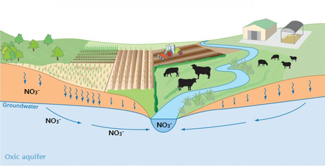
Elevated nitrate concentrations in both ground and surface water are a common problem in regions with intensive agriculture such as Flanders. Fertilizer restrictions have in many catchments been awarded with reduced nitrate concentrations, but not everywhere. In catchments with substantial nitrate-rich baseflow from groundwater, the response may be delayed due to long travel times of historically contaminated ground water travelling through the unsaturated zone and oxidized parts of the aquifer systems.

Ten catchments were selected: eight with a high and two with a rather low nitrate input from the baseflow. Nitrogen and water dynamics in the soil were simulated with the EU-rotate_N model on a daily basis for the last 50 years, using gridded data (50 x 50 m) on soil texture, soil organic carbon content, land use, crop type, manure production and fertilization restrictions. Where the groundwater table was shallow, yearly downward fluxes of nitrate and water at a depth of 90 cm were used as input for the groundwater model, which was developed by the UGent Laboratory for Applied Geology and Hydrogeology. For catchments with a deeper groundwater table, fluxes in the unsaturated zone were additionally modelled with Hydrus_1D. Where artificial drainage was significant, an estimated part of the fluxes was subtracted and considered as a direct input to surface water by drain pipes. Groundwater flow paths were traced by Modflow model calculations and age distributions were derived from the flowpath travel times and fitted with an exponential distribution function. Using these functions, the time response for nitrates in surface water was calculated with a convolution model.
This project is funded by the Flemish Land Agency (VLM).