Impact success story: Marine archaeology
Perhaps when hearing the term ‘marine heritage’ you think primarily of shipwrecks and hidden treasures, but did you know that there are also entire buried landscapes to be explored? The North Sea is a unique archaeological and palaeontological archive that until today has remained largely unknown and unexplored.
The North Sea nevertheless contains an unimaginable wealth of historical information (for example about shipwrecks, Roman and medieval coastal defences and habitations), as well as indications about past climate fluctuations and changes in flora and fauna.
The field of marine archaeology therefore gives us a glimpse into the past and teaches us about the climate and customs of our ancestors. It can also build the foundations for regulations and spatial planning.
Special finds
When scientists find a shipwreck at the bottom of the sea, it can tell them something about a war or trade during the Middle Ages, for example. This new knowledge is made available to society as a whole. This is how we learn more about our history. Most people therefore recognise shipwrecks as cultural heritage, but there’s so much more to find at the bottom of the North Sea. Prehistoric or Roman objects, for example. And bone material. The study of buried landscapes also makes it possible to map old coastlines and better understand the effects of climate change today on our coastal landscapes.
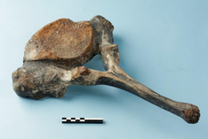
Geologist and researcher at Ghent University, Maikel De Clercq: “We found hundreds of walrus bones in Zeebrugge. Some of these fossils are displayed in information centres in coastal cities, but they’re usually taken to museums or other knowledge institutions and added to the collections there. They’re studied, dated and situated within a geological context. In other words: we find out why they were buried precisely there, for example because there was once a river. When I say that the sea level throughout history has often been one hundred metres lower, many people don’t know that.”
In general, little is known about the seabed among the general public. In particular, knowledge is limited about buried landscapes, how they originated and what happened to them. Maikel De Clercq: “We can find and reconstruct those landscapes. Our ancestors lived in them, we can see how man conquered Europe during the ice age, how peoples migrated, how they went to England, for example, or to the ‘lost Doggerland’. We’ve also come to know more and more about how landscapes reacted to past climate changes and sea level rise.”
SeArch
Maikel De Clercq also participated in SeArch, a project that aimed to map the unique marine archaeological archive at an acceptable cost and with sufficient legal certainty in the context of marine exploitation.
The SeArch project has led Belgium to become a leading international player in the field of marine archaeological research, and a pioneer in the sustainable management of marine heritage and integration of the protection of underwater cultural heritage in marine spatial planning.
Belgium is now sufficiently armed to fully implement the 2001 UNESCO Convention on the protection of the underwater cultural heritage.
For his doctoral research, Maikel De Clercq drew out hidden landscapes at the bottom of the Belgian North Sea. One of his most important findings is that the River Scheldt, which now runs through Ghent to Antwerp, used to run through Ghent to Zeebrugge and led to the North Sea at Ostend. A second arm of this old River Scheldt valley ran under Zeebrugge and there was a temporary land bridge between Belgium/Zeeland and England. Not all of this knowledge is new, but it was confirmed by Maikel De Clercq’s research. While everyone assumed that all signs of it were lost, we now know this is not the case.
Communication Award
Maikel won the Communication Award from the Flanders Marine Institute (VLIZ) for his doctoral research. With the prize money, he had an animation film made to show children and the general public how the ice ages and interglacial periods worked, how the landscape changed and how scientists such as Maikel took their measurements at sea. “I wanted to make the archaeological and palaeontological material and landscapes they were taken from more tangible. The public wants to see this, but not presented in a boring way. It has to be interactive.”
Maikel De Clercq dreams of further visualizing the landscapes discovered in order to make them accessible to the public. “We know what it looked like on the seabed and have fleshed it out into 3D surfaces, often representing dozens of square kilometres in size. The gaming sector has already shown interest in incorporating these landscapes from days gone by in their games. This would allow even more people to become acquainted with them. It would be nice to see in virtual reality what such a landscape looks like, how the rivers flow through it, how the weather gets colder, how the ice ages come and go. With prehistoric humans and mammoths passing by ...”.